
- Telecommunication
- Communication &
Information Technology - Security &
Surveillance - Audio Visual
- Test and
Measurement - Professional
Services
O'Connor's offers equipment for all frequency spectrums.
Solutions offered include Auxiliary Radio Systems, Digital microwave Radio Systems, Marine Navigational Aids Systems, Trunking Radio Systems and Aviation Navigational Aids System.
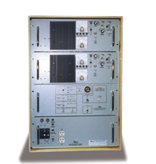
O'Connor's telecommunication expertise lies in systems designs, integration and commissioning of turn-key telecommunication systems. The turnkey services include project management, complete engineering and design, installation and testing and training.
You may choose from a wide line of integrated telecommunication systems, put together from established and reputable global brands that we work closely with.
Today O'Connor's has an added edge in the industry. We are widely known for outstanding professional services, particularly for our post sales services and training.
Our initiatives to minimize down time include:
• 24/7 customer care
• preventive maintenance and systems health checks
• remote diagnostic capabilities
• component level repair centers and more
-
Auxiliary Radio Systems
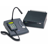
Auxiliary Radio Systems facilitates the daily operation of crews / workers in all the industries such as manufacturing factories, petro-chemical plants, marine fishery, mining, oil & gas platforms, transportation and etc.
VHF / UHF Hand portable and mobile radio, and HF SSB Radio are commonly used by onshore based operators to communicate with their crews and give instruction or send job assignment notes to their workers.
Offshore Auxiliary Radio Systems involve GMDSS Survival Craft / Life Raft Communication radio, VHF Marine Hague Plan radio, Crane Communication radio, HF SSB radio, VHF GTA radio and NDB; which meets IMO SOLAS compliance requirement besides supporting the daily operation of crews on the oil & gas platforms and supply vessels.
-
Digital Microware Radio Systems
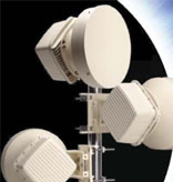
Digital Microwave Radio System is used to send and receive digital or analog signals such as telephone calls, television programs and internet data between two locations on a line of sight radio link.
The radio frequencies / spectrums range from 1 to 30 GHz, and is transmitted between the two locations with directional antennas to form a fixed radio connection. The radio link can be configured as 1+1 hot-standby, space diversity, frequency diversity, quad diversity and etc. to meet the customer's requirements and technical specifications. The requirement for a line of sight limits the distance of each radio link between two sites to 60km or less practically. However, when the standard Digital Microwave Radio System is unsuitable for requirements with longer radio path such as island and offshore oil & gas platforms; over the horizon or troposcatter Digital Microwave Radio System is provided to meet the client's need.
The Digital Troposcatter Radio System is unlike the standard microwave radio and instead, the radio wave is propagating and scattering in an area called common volume in troposphere, whereby the intersection of transmit and receive radio beam having useful scattering mechanism to effect the scatter communication.
Since the scatter communication is taking place at tropospheric region/layer and no line of sight is needed, the achievable radio distance between two stations can be as far as 300km based on the current resources available in the market and of course; it is subject to limitation and restriction implemented by authority of each country.
The Digital Microwave Radio System in the market presently consist of narrow band licensed DMR, License-exempted ISM band radio, over the horizon radio and etc. in the frequencies band of 2 - 38 GHz.
-
Marine Navigational Aids Systems
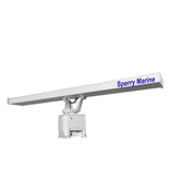
The Marine Navigational Aids System is designed to assist captains to determine a ship's position and safe course, warn them of dangers and obstructions in their navigation route from one place to another destination accordance to IMO rules and procedures.
The system involves Collision Avoidance System, Automatic Identification System (AIS), Marine Radio Beacon (RACON), Wave Monitoring System (WAVEX), Meteorology System, Automatic Radar Plotting Aids (ARPA), EPIRB, SART and etc.
-
Trunking Radio Systems
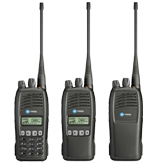
A better name for a trunked radio would be "computer aided radio" as it is the application of microprocessors and synthesizers that enable trunked radio systems to share a pool of radio channels between many groups of users.
Each pair or group of users have the exclusive used of a channel for the pre-programmed duration of their call.
Basically, there is Control Channel and multiple Traffic Channels which depend on the usage and application of the customer. The Control Channel performs allocation of Traffic Channels in the trunking radio system, whereas; the Traffic Channel provides communication path for the radio users.
The Trunking Radio System is able to provide individual call, group call, broadcast call, priority call, emergency call, short data messaging, status message, PSTN/PABX call and etc.
The systems available in the market comprising APCO P25, TETRA, Analog MPT1327 and etc.
-
Aviation Navigational Aids System
Integration, Testing and Commissioning of Communications, Navigation, and Surveillance/air traffic management (CNS/ATM) solutions comprising the following.
- a) Communications System (Comaids)
- Ground to Air Radio systems (G/A)
- Ground to Ground Radio systems (G/G)
- Aeronautical Information Service System (FIS)
- Voice Command and Control System (VCCS)
- Aeronautical Terminal Information System (ATIS)
- Multi-Channel Recording System (MCRS)
- ATC Consoles
- b) Navigation System
- Non-Directional Beacons (NDB)
- Doppler Very high frequency Omni-directional Radio range (DVOR)
- Distance Measuring Equipment (DME)
- Instrument Landing System (ILS)
- Remote Control Monitoring and Maintenance System (RCMMS)
- c) Surveillance/air traffic management
- Primary Surveillance Radar (PSR)
- Mono-Pulse Secondary Surveillance Radar (MSSR)
- Automatic Dependent Surveillance-Broadcast (ADS-B)
- Air Traffic Management System (ATM)
- Multilateration System (MLAT)
Successful Aviation Navigational Aids System involves piloting an aircraft from place to place without getting lost, breaking the laws applying to aircraft or endangering the safety of those on board or on the ground.
Ground base air navigation system involves the use of instruments and radio navigational aids for controlling the movements of aircrafts from one place to another. The instruments and radio navigational aids systems that are currently in use throughout the world are Non-Directional Beacon (NDB), DVOR/DME, Instrument Landing System (ILS), Aviation Radar, Aeronautical Ground Lighting System (AGLS) and Communication Aids.
Click to learn more on Post Sales Services


